
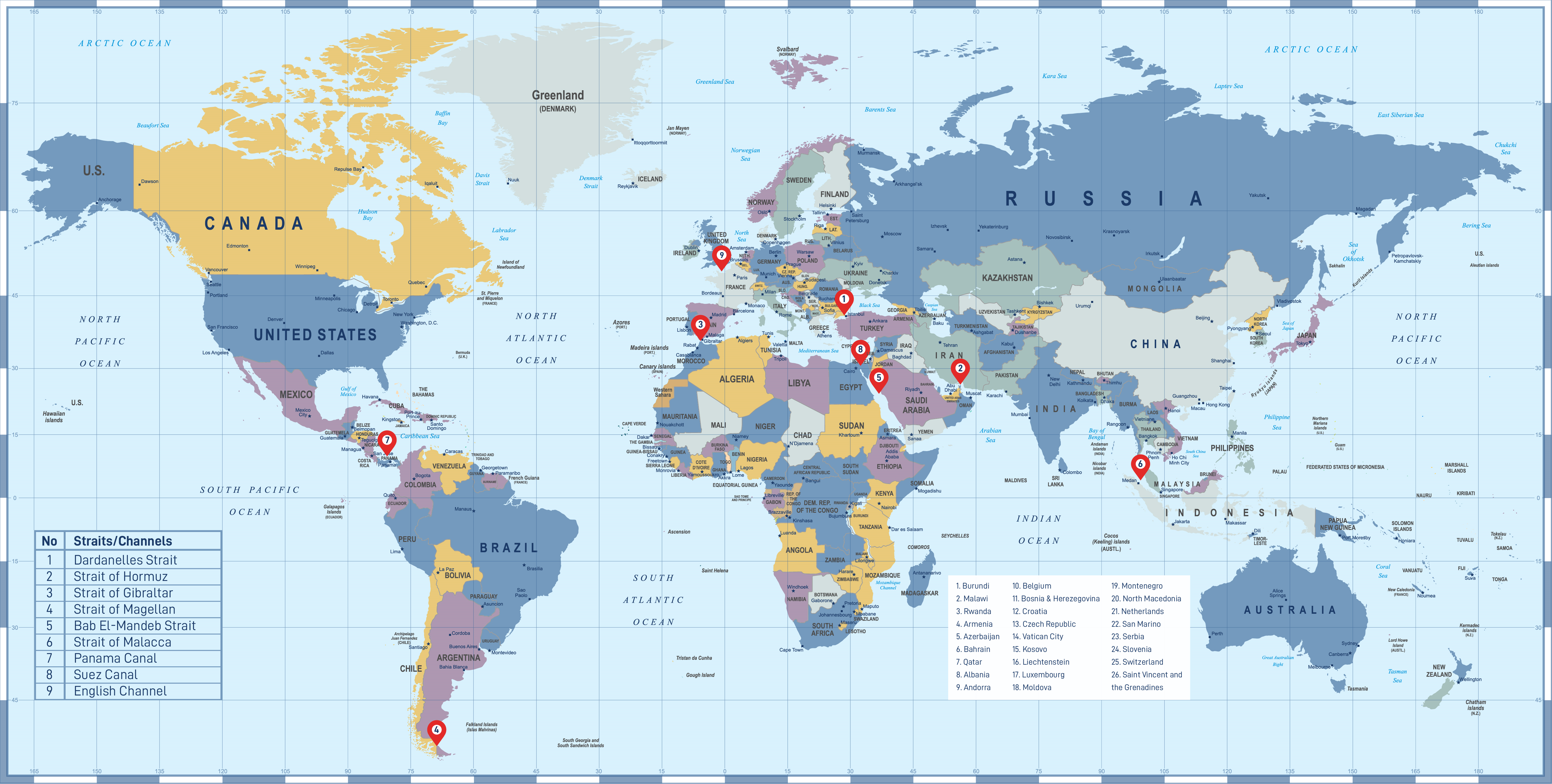
STRATEGIC WATERWAYS NAKILAT’S VESSELS NAVIGATE THROUGH
The main goal of the shipping industry is to transport cargoes of goods safely, easily, quickly, and efficiently to global destinations. Significant volume of maritime trades have been taking place within the strategic straits and major channels, providing safe and efficient shipping routes for the various types and sizes of ships to travel between the continents.
With the world’s largest liquefied natural gas (LNG) fleet, Nakilat’s LNG carriers transport about two-third of Qatar’s LNG annual exports to over 25 countries. During this process, our vessels traverse many important channels and waterways to deliver clean energy across the world.
Below are some of the world’s most important straits and channels used by global shipping companies to transport goods from one location to another.
WHAT IS THE DIFFERENCE BETWEEN A STRAIT & A CANAL?
- A Strait is a naturally formed, narrow, typically navigable waterway that connects two larger bodies of water
- It most commonly refers to a channel of water that lies between two land masses
- It is used for international navigation through the territorial sea between one part of the high seas or an exclusive economic zone and another part of the high seas or an exclusive economic zone are subject to the legal regime of transit passage
- Historically, straits have had great strategic importance as whoever controls a strait is likely to control the sea and shipping routes of the entire region
- A Canal is an artificial, man-made waterway that allows boats and ships to pass from one body of water to another
- Canals are also used to transport water for irrigation and other human uses
- A canal can be created where no stream presently exists, either the body of the canal is dug or the sides of the canal are created by making dykes or levees by piling dirt, stone, concrete or other building materials
- A canal can be constructed by dredging a channel in the bottom of an existing lake
STRAITS, CANALS & ROUTES THAT NAKILAT’S VESSELS TRANSIT THROUGH
Dardanelles Strait
As maritime waterways, the Turkish Straits connect various seas along the Eastern Mediterranean, the Balkans, the Near East, and Western Eurasia. Specifically, the Straits allows maritime connections from the Black Sea all the way to the Aegean and Mediterranean Seas, the Atlantic Ocean via Gibraltar, and the Indian Ocean through the Suez Canal, making them crucial international waterways, in particular for the passage of goods coming in from Russia.
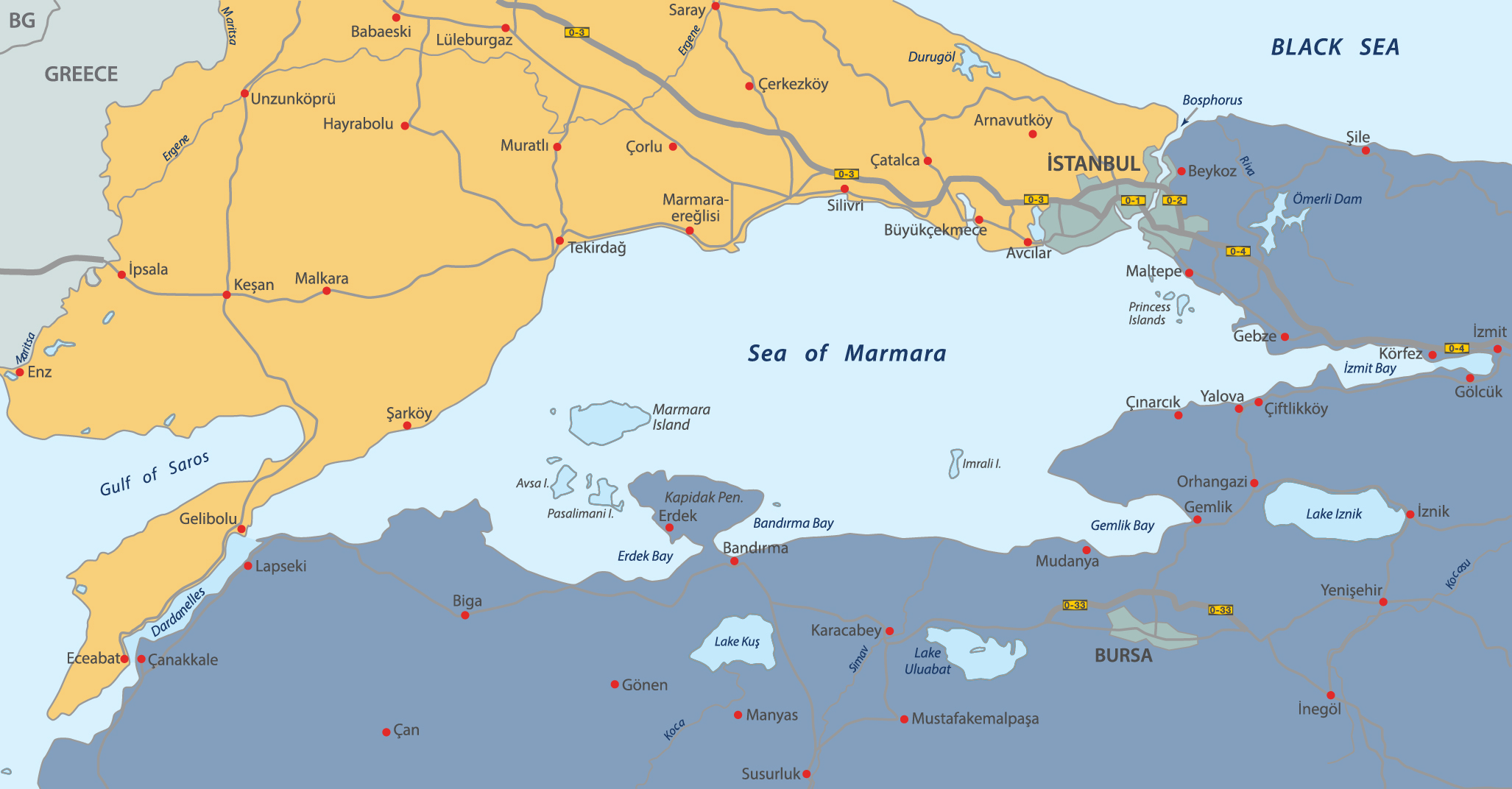
- One of the world’s narrowest straits used for international navigation, the Dardanelles connects the Sea of Marmara with the Aegean and Mediterranean Seas, while also allowing passage to the Black Sea by extension via the Bosphorus
- The Dardanelles Strait separates Asian Turkey from European Turkey, thus separating the two continents
- All types of Nakilat’s LNG & LPG carriers (Q-Max, Q-Flex, conventional, and VLCC) can pass through The Dardanelles Strait
- Typically, Nakilat’s vessels utilize this route to head to Marmara Ereğlisi LNG Terminal
Quick Facts!
| Length | About 61 km |
| Width | 1.2 – 6 km |
| Depth |
|
Source: Wikipedia & Britannica
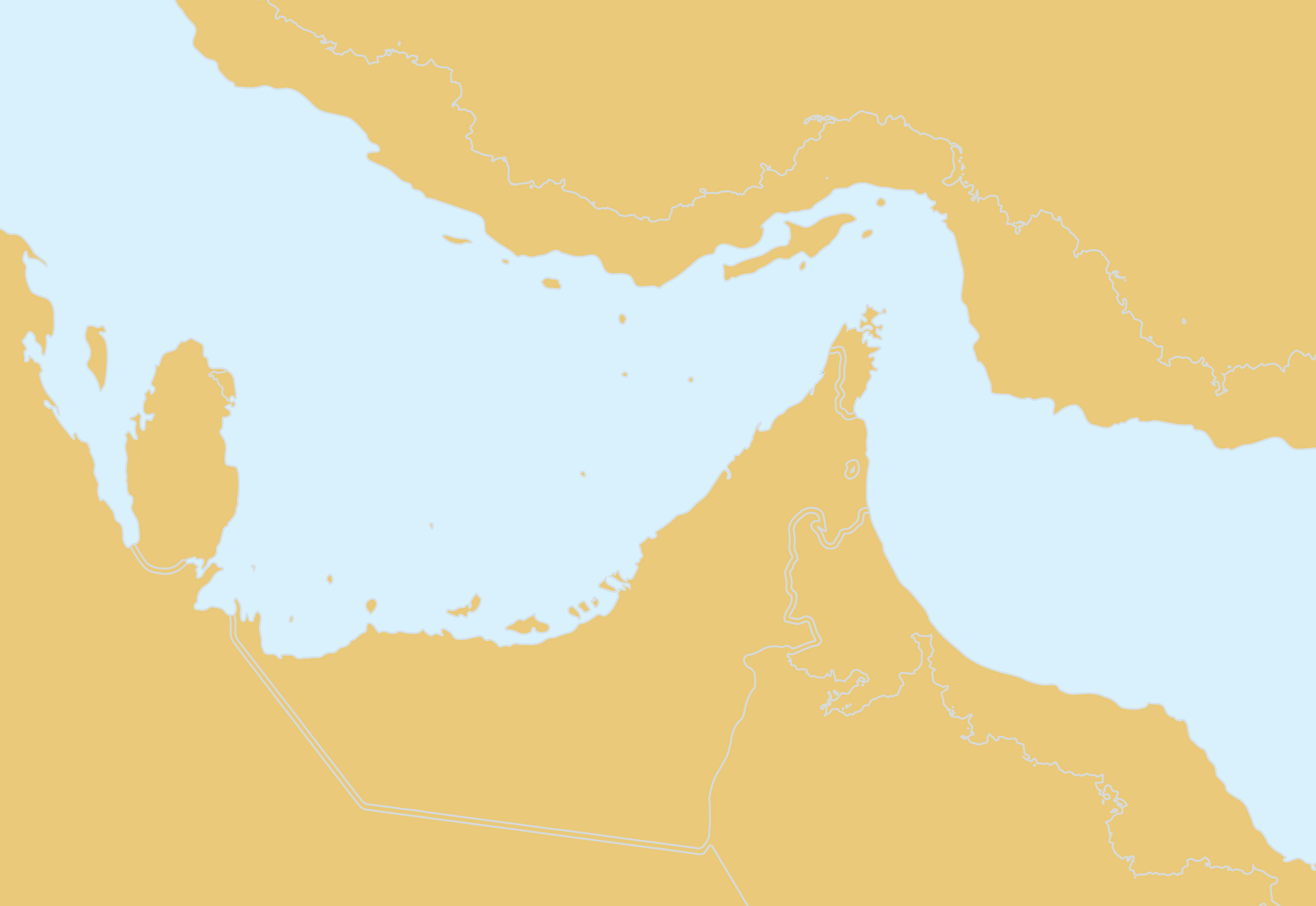
Strait of Hormuz
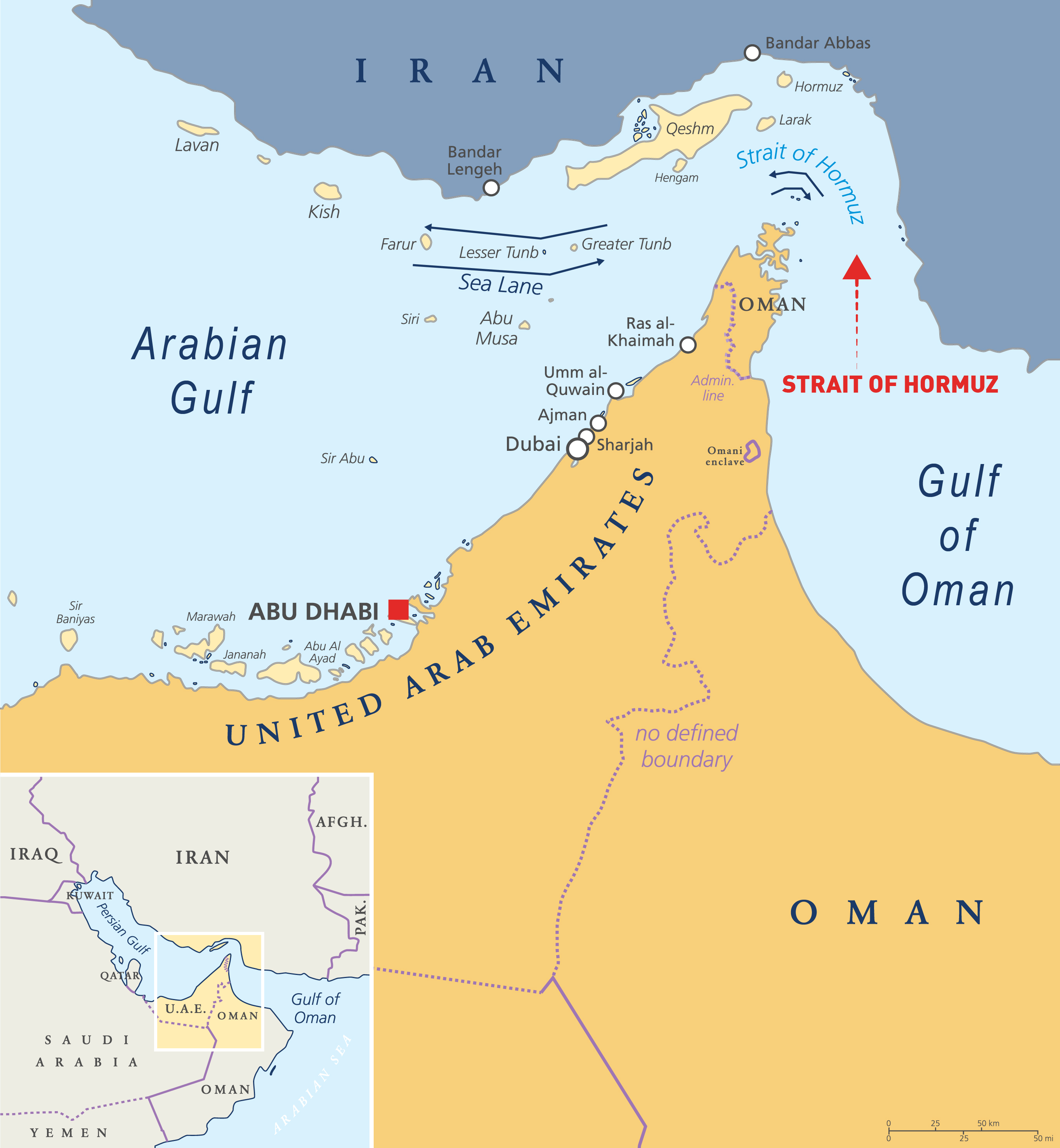
- Located between the Arabian Gulf and the Gulf of Oman, this strait is the only sea passage from the Arabian Gulf to the open ocean
- The Strait of Hormuz is the world’s most strategically important waterway because of the large volumes of oil that flow through the strait
- Approximately one fifth of the world’s LNG and almost 25% of total global oil consumption passes through the strait, making it a highly important strategic pathway for international trade
- Almost all Nakilat LNG & LPG cargos from Qatar pass through this critical strait except those headed to Kuwait, delivering energy to worldwide destinations
Quick Facts!
| Length | About 167 km |
| Width | Vary from 39 – 96 km |
| Depth | No more than 60 m |
Source: Wikipedia & Britannica
STRAIT OF GIBRALTAR
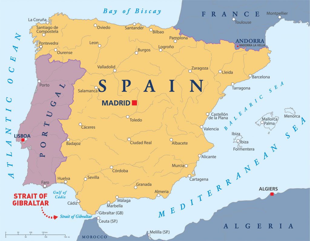
- The Strait of Gibraltar separates the Atlantic Ocean from the Mediterranean Sea
- This 13-kilometer-wide waterway also separates Europe and Africa, with Spain and Gibraltar on the left and Morocco on the right
- Vessels such as passenger ferries can cross between the two continents every day in as little as 35 minutes
- Until the opening of the Suez Canal in 1869, the Strait of Gibraltar served as the only access point to the Mediterranean Sea which served as a crucial waterway for vessels traveling between the Atlantic and Mediterranean
- Nakilat’s vessels pass through this channel to reach Northwestern Europe such as LNG terminals in Flushing (US), Zeebrugge (Belgium), Rotterdam (Netherlands), Swinoujcie (Poland), and Dunkerque (France) and United Kingdom (UK) ports, as well as North America
Quick Facts!
| Length | About 58 km |
| Width | 13 km at narrowest points |
| Depth | Between 300 – 900 m |
Source: Britannica
STRAIT OF MAGELLAN
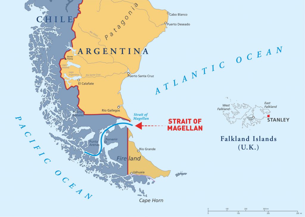
- Located in southern Chile separating mainland South America to the north and Tierra del Fuego to the south
- Most important natural passage connecting the Atlantic and Pacific oceans
- A difficult route to navigate because of the unpredictable winds and currents and the narrowness of the passage, but it is shorter and more sheltered than the Drake Passage, which was the only other sea route between the oceans until the construction of the Panama Canal
- Nakilat’s Q-Flex LNG Carriers (LNGC) & Very Large Gas Carriers (VLGC) have transited through this strait
Quick Facts!
| Length | About 570 km |
| Width | About 2 km at its narrowest point |
| Depth | Max depth of 1,080 m |
Source: Wikipedia & Britannica
BAB EL MANDEB STRAIT
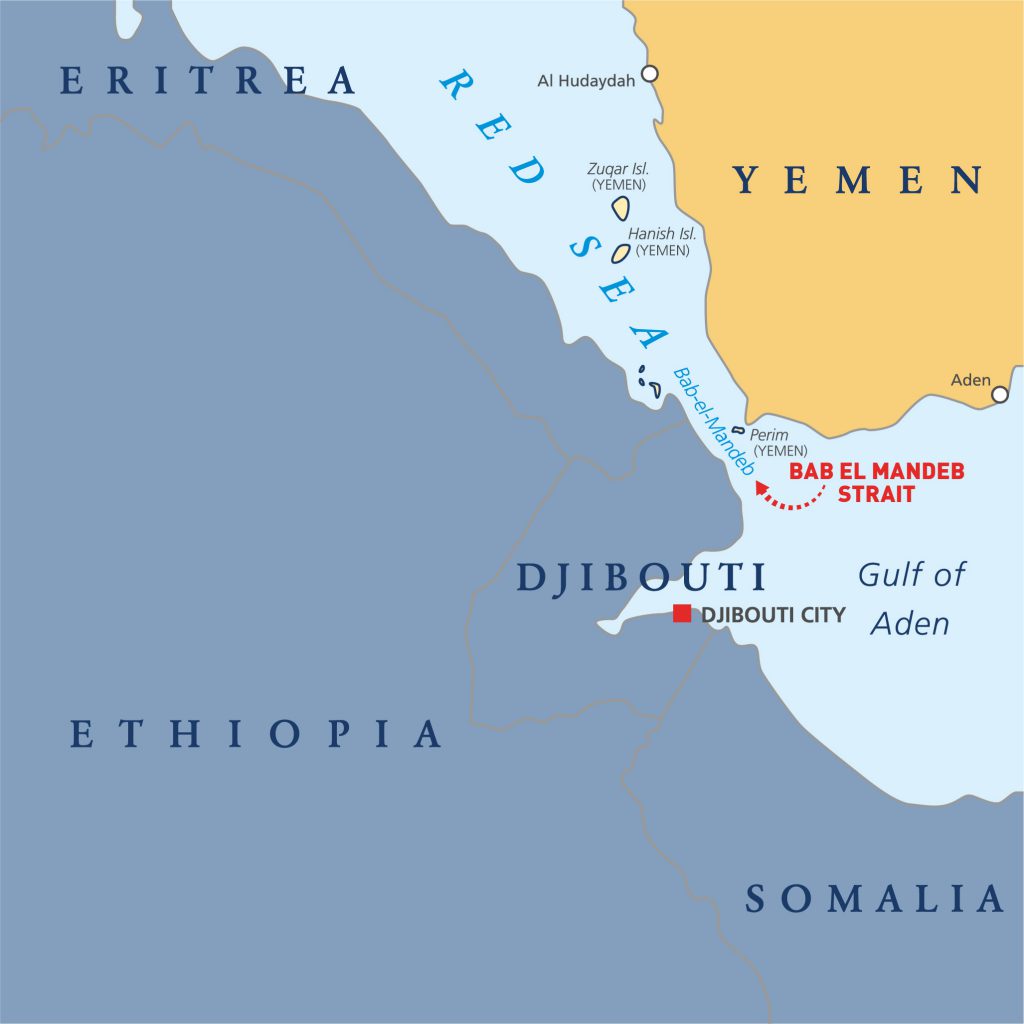
- Know as the “Gate of Tears”, Bab El-Mandeb Strait is a narrow neck of water that separates the Red Sea from the Indian Ocean
- It’s bordered to the northeast by Yemen and to the southwest by Eritrea and Djibouti. The strait is divided into two channels by Perim Island
- This strait forms a vital link on the trade route between the Mediterranean and Asia
- The distance across is about 20 miles (30 km) from Ras Menheli in Yemen to Ras Siyyan in Djibouti
- The island of Perim divides the strait into two channels, of which the eastern, known as the Bab Iskender (Alexander’s Strait), is 2 miles (3 km) wide and 16 fathoms (30 m) deep, while the western, or Dact-el-Mayun, has a width of about 16 miles (25 km) and a depth of 170 fathoms (310 m)
- This is an important route for Nakilat’s vessels to pass through to Red Sea from Qatar
STRAIT OF MALACCA
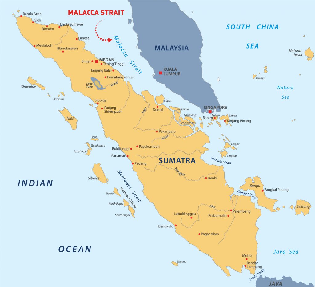
- A narrow, stretch of water between the Peninsular Malaysia and the Indonesian island of Sumatra
- Main shipping channel between the Indian Ocean and the Pacific Ocean. From an economic and strategic perspective, the Strait of Malacca is one of the most important shipping lanes in the world.
- Over 134,000 vessels pass through the strait each year making it the busiest strait in the world, carrying about 25% of the world’s traded goods, including oil, Chinese manufactured products, coal, palm oil and Indonesian coffee. About a quarter of all oil carried by sea passes through the Strait, mainly from Persian Gulf suppliers to Asian markets.
- This Strait is a lifeline for Japan, with more than 80% of the country’s oil imports transported through it
- Nakilat’s vessels pass through this Strait to reach Far East destinations such as China, Japan, South Korea, etc.
Quick Facts!
| Length | 800 km (funnel shaped) |
| Width | ~2.8 km at its narrowest |
| Depth |
|
Source: Wikipedia & Britannica & The Nippon Foundation
PANAMA CANAL
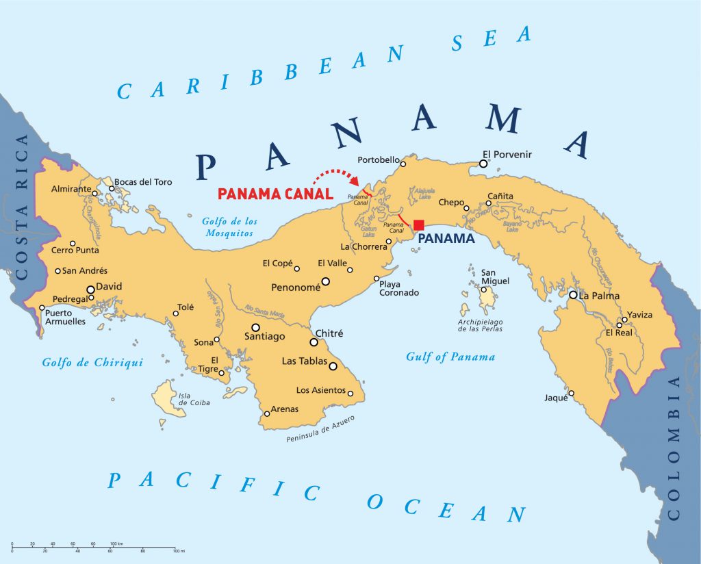
An artificial 82 km (51 mi) waterway in Panama, allowing ships to pass between the Atlantic Ocean and Pacific Ocean, saving about 8,000 miles (12,875 km) from a journey around the southern tip of South America, Cape Horn
Operations of the Panama Canal
- It takes approximately fifteen hours to traverse the canal through its three sets of locks (about half the time is spent waiting due to traffic)
- Locks allow a canal to go up and down hills. If there were no locks in the Panama Canal, the Atlantic and Pacific oceans couldn’t flow into each other, because there are hills in between
- Ships passing through the canal from the Atlantic Ocean to the Pacific Ocean actually move from the northwest to the southeast, due to the east-west orientation of the Isthmus of Panama
- Since the opening of the expanded canal, Nakilat-operated LPG Carrier Umm Laqhab and joint venture operated Q-Flex LNG Carrier Al Safliya have transited the canal
- Q-Max and Q-Flex type LNG Carriers can also now transit the newly expanded Panama Canal, as the expansion allows double the capacity by adding a new lane of traffic allowing for a larger number of ships, and increasing the width and depth of the lanes and locks allowing larger ships to pass
Quick Facts!
| Length | 82 km |
| Width | Minimum 150 m;
Maximum 300 m |
| Depth | 14 – 26 m |
Source: Wikipedia & Britannica
SUEZ CANAL
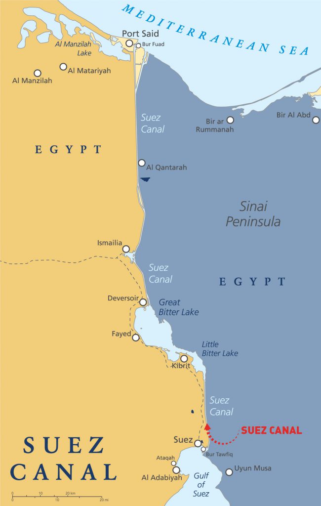
- Connects the Mediterranean Sea to the Indian Ocean via the Red Sea, hence enable a more direct route for shipping between Europe and Asia, effectively allowing for passage from the North Atlantic to the Indian Ocean without having to circumnavigate the African continent
- The waterway is vital for international trade. Since the canal does not cater to unregulated two-way traffic, all ships transit in convoys on regular times, scheduled on a 24-hour basis.
- This canal is large enough for all Nakilat’s Q-Max and Q-Flex type LNG carriers to pass through to reach Mediterranean, Europe and North American ports
- You may also be interested in reading more about the history and 9 Fascinating Facts about the Suez Canal!
ENGLISH CHANNEL
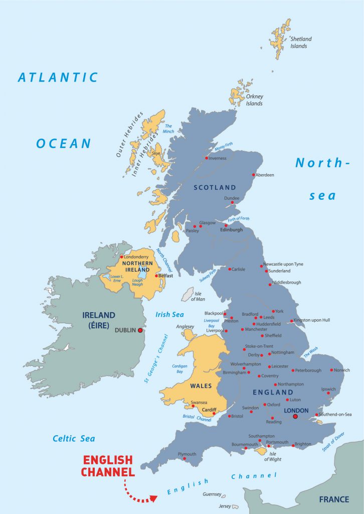
- Part of the Atlantic Ocean, separating the island of Britain (part of the UK) from northern France and joins the North Sea to the Atlantic Ocean
- Today, the English Channel is one of the busiest shipping lanes on the planet
- The common word channel was first recorded in Middle English in the 13th century and was borrowed from Old French chanel, variant form of chenel “canal”
- The French name La Manche has been in use since at least the 17th century. The name is usually said to refer to the Channel’s sleeve (French: la manche) shape
- Nakilat’s vessels pass through this channel to reach Northwestern Europe such as LNG terminals in Flushing (US), Zeebrugge (Belgium), Rotterdam (Netherlands), Swinoujcie (Poland), Dunkerque (France), and Isle of Grain (England) among others
CAPE ROUTE
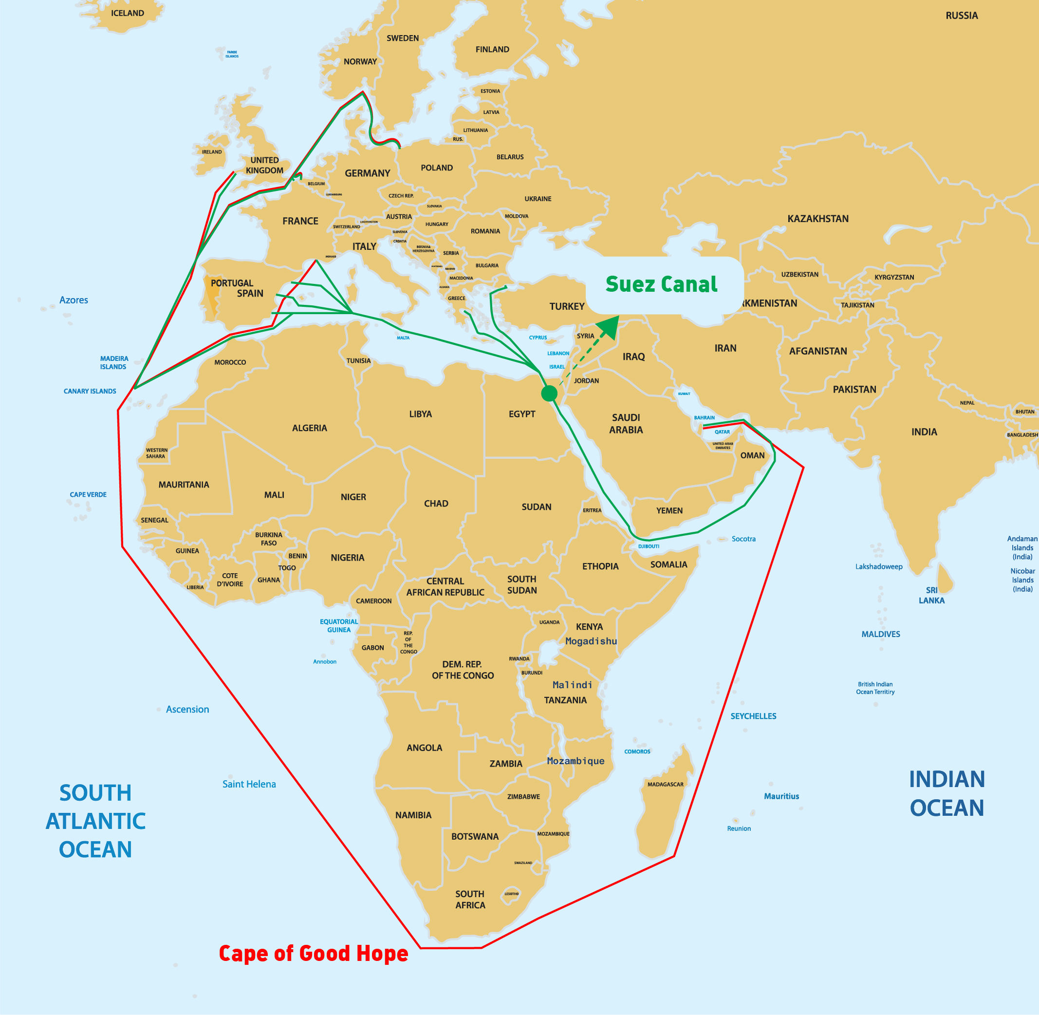
- The Cape Route as it commonly known, is a shipping route from European coast of the Atlantic Ocean to Asia’s coast of the Indian Ocean passing by the Cape of Good Hope and Cape Agulhas at the southern edge of Africa
- The first recorded completion of the route was made in 1498 by Portuguese explorer Vasco da Gama
- The route was important during the Age of Sail used by European East India Companies, but became partly obsolete as the Suez Canal opened in 1869
- All Nakilat’s vessels can pass through this channel to travel between Asia and Europe
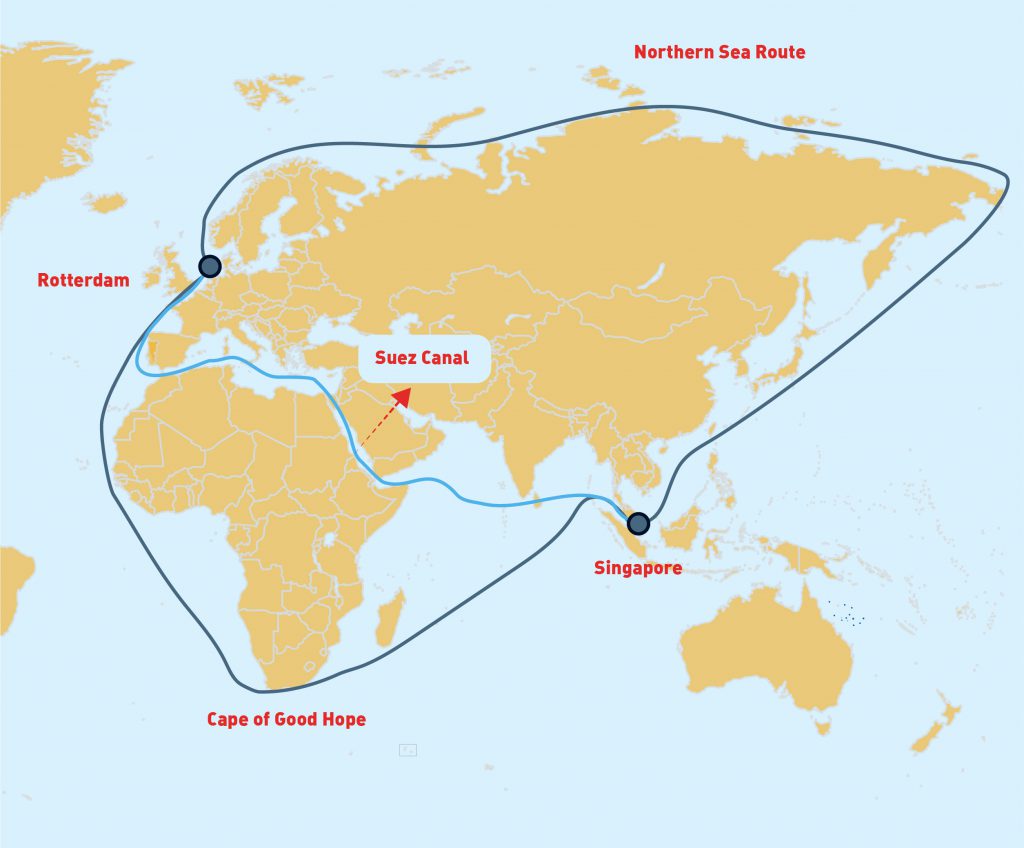
NORTHERN SEA ROUTE
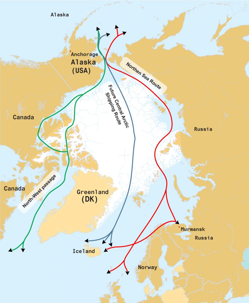
- The Northern Sea Route (NSR) is a shipping lane between the Atlantic Ocean and the Pacific Ocean along the Russian coast of Siberia and the Far East, crossing five Arctic Seas: the Barents Sea, the Kara Sea, the Laptev Sea, the East Siberian Sea and the Chukchi Sea
- The entire route lies in Arctic waters and within Russia’s exclusive economic zone (EEZ). Parts of this route are free of ice for only two months per year.
- Among the advantages of North Sea Route is the distance from Northern Europe to China and vice versa which is approximately 40% shorter than via the Suez Canal or 60% shorter via the Cape of Good Hope, hence substantially reduces transportation time, fuel consumption, environmental emission as well as eliminates piracy risk. This further results in cost savings by generating return cargoes from the Far East.
- This route is open for larger and a variety of vessels, hence all Nakilat’s LNG and LPG vessels can pass through this route
Source: Wikipedia
Now you know more about the commercial and strategic importance of these straits and channels to not only Nakilat, but the entire global and shipping maritime industry. Don’t forget to share this knowledge with your friends & families!